More About Chitta Katha Lake, Kashmir
Chitta Katha Lake is a wonderful lake in the Shounter Valley of Azad Kashmir. It is 13,500 feet (4,115 meters) above sea level. Chitta Katha is a regional name that means “White Stream.” The inception of Lake Chitta Katha Sar is the Chitta Katha stream, which flows from Mount Harri Parbat. This Mountain is a religious place for Hindu followers, who relate it to Lord Shiva and the eternal sanctuary of their Lord, Kailash.
Chita Katha Lake is accessible via a rough but beautiful, scenic trek.
Upon arrival, bewitching beauty and supernatural charm mesmerize tourists. The jeep track starts from Kel to Domail Bala. It is a rough shingle road 20 kilometers (12 miles) long. The hiking trek starts along a 5-kilometer (3.1-mile) stretch of lush green terrain. Kel is the base camp for the lake.
The lake is accessible from Kel via a 20-kilometer (12 mi) jeep track, followed by a 5-kilometer (3.1 mi) hike. Kel is the base camp for this lake.
Trek Overview
| Details | Information |
| Hike Difficulty | Moderate-Difficult |
| Trail Length | 8.6km (5.4 mi) |
| Elevation Gain | 1,260m |
| Typical Hike Duration (One-way) | 8 Hours |
| Trail Head | Houz or Upper Domail |
| Chitta Katha Lake Height | 4,090 m (13,420 ft) |
| Hike Season | July to October |
| Campsite | Dak-1 and Dak-2 |
| Guide | Available from Houz, Dak-1 & Dak-2 |
| Porters | Available from Houz, Dak-1 & Dak-2 |
| Car Parking | Available at Kel |
The main attraction during the trek to Chitta Katha Lake
Dhani waterfall
Kuttan
Jagraan resort
Keran
Kel
Domail
Shounter
Sapoon lake
Chita Khatha lake
Possible Itinerary
Day 01 – Leave Islamabad at 1 am in the night in a booked vehicle. Breakfast at Muzaffarabad, Lunch at Keran. Reach Kel and ride on jeeps toward Upper Domail. Dinner and Night stay in camps at Upper Domail.
Day 02 – Breakfast at Upper Domail. No lunch will be served today, but daypacks will be given before the start of the trek. Dinner and Night stay in camps at Dak-1/Dak-2.
Day 03 – Breakfast at Dak-1/Dak-2. Start hiking towards Chitta Katha Lake. No lunch will be served on this day; instead, daypacks will be given before the start of the trek. Dinner and night stay in camps at the lakeside.
Day 04 – Breakfast at Chitta Katha Lake. Trek back to Upper Domail. Lunch at Upper Domail. Ride on the jeep back to Kel. Dinner and a night in a hotel in Kel.
Day 05 – Breakfast at Kel. Start the return journey towards Islamabad. Lunch at Keran/Muzaffarabad. Reach Islamabad.
Logistics
- For the entire trip, you essentially need:
- Warm clothes
- Rain Coat
- Trekking Joggers
- Sunblock and shades
- Essential medicine and a quick Basic First Aid Box
- Energy Boosters such as energy bars, dates, candies, and chocolates
- A torch with extra batteries
- A Swiss knife
Get them from Kel or Shounter
- Tent/camp
- Sleeping bags
- Basic toiletries and baby wipes
- Hiking or Trekking Sticks
- Water bottles
- Canned Food.
There are nomadic families or localities you will find during your hike, and they can cook for you.
Kel T0 Shounter Valley
We have to leave early in the morning and have breakfast in Kel Town, then head towards 9000 feet high Upper Domail (Junction Point of Two Streams), which is 20 km away and a two-hour jeep drive. You should also hire a guide if you are here for the first time. Because there is no proper foot track or trail to Chitta Katha Lake. Ahead of the 16,500-feet-high Hari Parbat Mountain, along it, there is an 8-kilometer trek to the 13,500-foot high-altitude Chitta Katha Lake, which is located in the lap of the Hari Parbat Mountains.
The sun was fully raised and we were all in the Jeep, heading towards the Upper Domail. The road was very rough and dangerous. However, our driver was highly skilled and had experience on this track many times. One more thing: there should be no problems except for frightened passengers. Local families on the way can provide you with basic food and sleeping bags. On the right and left sides of the track stood giant three-story traditional Kashmiri houses, surrounded by green fields. Ahead of the field,s there were many green and slightly brown mountains. Many streams and rivers were flowing in the lap of these mountains.
Domail Valley
A sign for a village just appeared: Lower Domail Village. The mesmerizing view of the Hari Parbat Mountains is visible from here. S.com signals have ended at this point; after that, no signals, just lost in beauty.
Sarwali Peak and Hari Parbat
Attention please, here I am going to share some precious geography. The highest peak in Azad Jammu and Kashmir is called “Sarwali Peak”, also known as Dabbar Peak and Toshe Ri. Its height is 6326 meters (20,754 feet). Then the second is “Hari Parbat,” which is 16,500 feet high and has a heavy technical climb. Importantly, although these two mountains are in independent Kashmir, according to Mountain Science, they are a little like “Nanga Parbat.” Yes, the unsophisticated mess is a wide range. Sarwali and Hari Parbat are in the same Nanga Parbat range, which enters the Azad Kashmir. Starting from Chitta Katha Lake, the top of Nanga Parbat can be reached “from top to top”. After that, Hari Parbat continued to appear again and again, a towering, impassable wall.
Nangi Mali Mountain
“That’s a Nangi Mali Mountain in front of us. Rubies are extracted from it nowadays. Ruby or red Yaqoot is a precious stone.” Looking at this beautiful but clumsy and treeless mountain, it was as if it were a quite different mountain. It was reported that some companies have drilled mines in the mountain and they are extracting ruby. The track ended after a long time. A vertical wall was standing in front, and the waterfall was on one side. There was too much climbing. Aside from the feet, the hands were climbing as well. A beautiful “Nangi Mali” scene was captured here. The autumn colors are in the background of the trees. Nangi Mali..
Shounter Valley to Dak-1
After walking a kilometer along the road, on the right side, there were many steep footpaths leading up to Shountar Stream. There was a bridge somewhere we had to cross to get back on track. Now there were two routes to the Chitta Katha Lake. Route 1 passes through the Stony Mountains. You will have to trek to the top of a small, greenish mountain and then descend to a valley called DAK. This is quite a long track route – takes about 5-6 hours. And there is a dangerously steep stony ridge that you have to cross about 100 meters. First, you have a stream on your way, so remember to fill up your water bottles. There is no other water source on the way to DAK 1.
Second Route goes right along the bank of a stream that comes from DAK 1 and 2. This is a shorter, steeper route than the first one and will take you about 3-3.5 hours, but it is not recommended. Winding on the trails, I looked into the valley we were about to enter. To the right was the beautiful Alpine forest, with autumn colors and greenery visible in the distance, and a sharp, milky-colored stream flowed from the top. The same stream is called “Chitta Katha” because in the local language, katha means a Nallah. The white drainage is visible everywhere.
Chitta Katha Village
The track didn’t feel too long, but the valley’s characteristics suggested it would rise immediately. Crossing the bridge, the sandy track began on the left side of the valley and was a steep, slippery cliff. Upstairs was a Chitta Katha Village with women working in the fields. After the village, the first few hundred meters to a foot-wide trail were quite suitable, but then it started to rise. The birch forest began. This is the same birch, whose white bark is just as layered as the pages of a book. Ten minutes later, the forest was over, and we saw the most beautiful scenery ever. The fast-flowing milk stream was approaching. So much terror was taking place.
As the elevation increased a bit, the track curved to the right along the bank of the Nallah. Now we were moving from top to bottom on the wet rocks. Of course, if more and more water came into the drain, the path would have ended. On the left was the same vertical wall. The area had a variety of scented herbs. The track was quite exhausting, but we reached a high enough level. The top of the spot was a cup-like field surrounded by Hari-Perbat. But there was a glacier in the valley between the two peaks of the Hari Parbat, and there was fog. And the two peaks are very striking.
There were shepherds’ houses in this field called “Bahk.” Trekkers call this place “Dak-One”. It is not known whether it is a “deck” or a ship’s destination. Anyway, we were here in half an hour.
Dak-1 to Dak-2
We will have to move from Dak-1 to Dak-2; the distance is certainly less than a kilometer. But it is a very steep climb, ending with crossing a steep glacier on top of the stream. You can stay at Dak-1 or Dak-2 for a night. The beautiful grounds had purple flowers. After passing among these flowers, we reached the bottom of the mountain in front and started climbing up the zig-zag. It took 40 to 45 minutes to climb. That is, it was a shortcut. On the top right, there was “Dak-2,” and we were above them.
Dak-2 to Chitta Katha Lake
We had lost our hearts at this stage (Dake-2), but the scene there was incredibly beautiful. Waterfalls were falling from the high altitudes on each side. A large waterfall was erupting from the bottom of the Hari-Perbat Mountain and forming more branches in the rocks. The White Drain of Streams of Chitta Katha was flowing through a wall on the right side. According to local people, the water from Chitta Katha Lake flows deep into the rocks, so it comes down far enough that the waterfalls erupt here.
We should go up to the left. Cross the top stones and go to the middle of the Hari-Parbat Mountains, even go above all the waterfalls. Further ahead, on the right, there is a clear edge of hard rock that marks the Chitta Katha Lake.
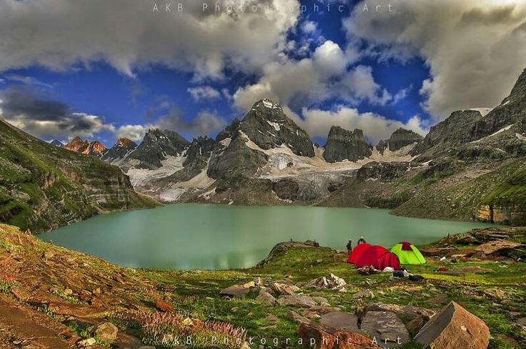
Chitta Katha Lake
As we were getting higher, the depths were getting deeper and more dangerous. The track wasn’t there; it just kept going. After the rocks came a place made of vertical angles, likely formed by a single slippery rock. Slipping on it meant falling uncontrollably into the thousands of feet below.
The day was winding down, and we were passing through the lap of Hari Parbat. Finally, we reached the second part of Hari Parbat, which had a lake just across the high-altitude ridge. But this elevation was not ending. The day was dwindling, and fears were growing whether the return would be the same and whether it would be in the dark!!
We reached the lake as soon as possible. It was evening, and the cold was getting colder. Suddenly, the water of the lake appeared.
It was not the smiling lake we saw in the pictures. It is a gray lake whose waters are littered with terror. In the background, the snow-covered peaks were lined up as if ready to be invaded. It was exactly the Arctic climate, with six months of night.
The cold, snowy, and windy nights did not allow us to stay on the lake for long. We turned back
Must Read: Rush Lake Trek
Suggested Read: Beautiful Ansoo Lake Trek
Chitta Katha Lake Trek
Chitta Katha Lake isn’t easy to see, as it’s about a 20 km jeep track from Kel to Upper Domail & then (16 to 18 km) 8 to 10 hours arduous hike, but it’s gorgeous and completely worth it. Moreover, the fact that it isn’t easy to access helps maintain this picturesque lake’s peaceful, secluded vibe.
When to Visit:
The lake is accessible from July to September, but if you go in August, you’ll catch an amazing abundance of wildflowers during the hike.
Suggested Read: Trek to Dudipatsar Lake
Must Read: Trek to Saral Lake
Fast Facts
Location: Chitta Katha Lake, Shounter Valley – a sub valley of Neelam Valley, Azad Kashmir
Route: Islamabad to Kel, around 300 km via Muzaffarabad, Kundal Shahi, Keran, Dowarian & Sharda.
Elevation: 13500 feet – 4100 meters
Kel to Domail Bala (Shounter Valley) 20 km in 3 hours
Trek Distance: 16 to 18 km approx (calculated through Samsung Health App)
Time: 8 to 10 hours
Difficulty: Advanced
Where to Stay: Camping only
Best time to go: July to September
Must Read: Katora Lake Trek Kohistan
Must Read: Princess of Lake – Ratti Gali Lake
Trekking Routes:
i) Domail Bala village – Dek 1 – Dek 2 – Hari Parbat Waterfall & the Lake
ii) Houz village – Dek 1 – Dek 2 – Hari Parbat Waterfall & the Lake
The Ultimate 3-Day Itinerary:
Day 1: Leave from Kel at 8:00 am & reach Domail Bala at 11:30 am, Visit Shounter Lake & Waterfall, which are 4 km from Domail Bala (the base camp). Afterward, return to Domail Bala & hire a porter/guide to carry extra luggage. Start your trek at 2:00 pm & reach Dek-1 well before 5:30 pm. Set up your camp on the bank of Chitta Katha Nullah & enjoy this one-of-a-kind atmosphere.
Day-2: Leave for the Lake at 9:00 am, enjoy the breathtaking views along the route, stay for some time at Dek-2, then head to Hari Parbat Waterfall & stay there for an hour, then continue & reach the Lake by or before 5 pm. Set up camps & start enjoying the sunset at the Lake.
Note: The best time for photography at the Lake is 5:00 pm to 6:30 pm; never miss this opportunity as I did.
Day-3: After packing, leave at 9:00 am, you’ll reach Domail Bala on or before 1:00 pm. Then leave for Kel & stay at Arang Kel & enjoy the sunset.
Access to the lake is via a 2-hour jeep trek from Kel to Shounter Valley.
And then a hike of 7 to 8hrs upto lake
Must Read: Mesmerizing Karomber Lake Trek

